This thread is for discussing the geography of the continent stories so far take place in.
I haven’t thought much about geography, and have avoided making a world map because I feel like fantasy writers tend to waste a lot of time making maps before they’ve written anything.
What can be inferred from the stories written so far, and thus should be considered canon, is the following:
- Nor is NORse inspired NORthern land with NORdic folks. Get it? Bask in my brilliant naming scheme. Part of me thought I’d rename it later, but I kind of like it.
- Yoba is hot and sunny. Probably a mixture of deserts and tropical climate.
- Arvel and Tophet have a shared history.
- Tophet is Yoba’s hostile neighbor
- Arvel is the most economically powerful and the center of trade.
- The five countries are the main political powers and landmasses on the continent, and they all have dealings with each other, including a round table where representatives meet in Arvel.
- The capital of of Arvel and the grandest city on the continent is called Zenith.
- Yoba’s capital was recently taken over by Tophet. The capital has no name as of yet. But there is some smaller city or town near the capital called Bahira.
Given these facts, I took a whole three painstaking minutes to create a world map on a sticky note.
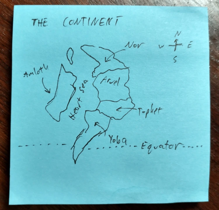
Besides not wanting to waste time, I make such a low effort contribution because it’s intended to be open for discussion. The layout could totally change as places and stories are added. Moreover, I don’t know much about real-life geography or climates or how those things have impacted history, so I leave it to others for now to suggest ideas.
A few geographical notes.
One is that for Yoba to have a coastal desert, the south of the continent probably features a high mountain plateau in its the center, with the desert in the rain shadow and a very lush coast on the other side. This probably doesn’t connect to the mountains in Nor, otherwise you end up with desert all along one coast. So you have highlands in the north, lowlands in the center, and highlands in the south again.
For Arvel to be a trade center, it is probably interspersed with navigable rivers. I mentioned a Noravar River in the Kothra geography post, so this could be the spine of the continents northern watershed, ending in a delta and a major trading port on the Heart Sea in southern Arvel.
With Amloth on an island, the elves are probably pretty capable sailors. Southern Amloth is definitely in the sub tropics, and probably has things like mangroves and saltwater wetlands. Northern Amloth is probably more temperate. This may lead to different elven subcultures depending on the trees, terrain types, and affinity for the water.
Those are helpful notes. To take a step back from the drawing, some of this also sort of depends on the scale, right? Which is so far undecided. Let’s say the planet is earth-sized, with the same range of climates. I then propose that to have a diverse, yet somewhat contained setting, it should be an isolated continent, but roughly analogous to this section of earth in terms of climate.
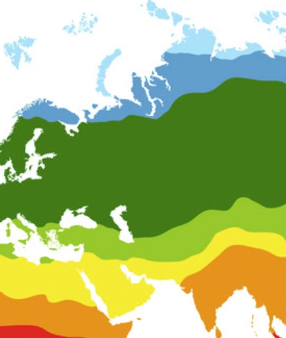
That keeps things easy to grok, at least for a western audience: top of the map is arctic, bottom is as hot as it gets. In the middle, Arvel, Tophet and northern Amloth could then have a temperate, four-seasons climate we associate with Europe and, by extension, classic European-inspired fantasy.
The length of the continent would then be something in the ballpark of 5000 or 6000 miles from North to South. The people on that continent may not be well-informed about who and what is across the ocean.
The portion of the Heart Sea between landmasses is then analogous to the Mediterranean sea: a not-too-treacherous saltwater sea full of trade routes, with high boat traffic from all the surrounding countries.
Biomes I easily picture in Yoba include a significant amount of desert, along with some lush jungles, savannahs, maybe plateaus and plains. I think of the whole region of southern Eurasia which includes the Arabian peninsula, India, Thailand. Given your notes, and depending on what we’re going for, I wonder if Yoba should then be less skinny, or at least have a wider northern end before tapering off, like Mexico or India.
It also feels like Nor could be bigger in sheer size, to play into the trope of a vast, sparsely inhabited cold wilderness – which is of course inspired by real life, like northern Canada, Russia, and Greenland.
Yeah, I think most of that makes sense. For Yoba’s biomes, we basically need to choose where we want the desert to be and set up a range of mountains to case a rain shadow (geologically simplest way to get a hot desert). One thought is to put them on the Tophet-Yoba border rather than in the center of the area. That lets us do a rain shadow in the center while letting both coasts be more temperate/jungle-y. It also creates very obvious transportation routes between Yoba and Tophet.
Another interesting note is that as currently set up, the western coast is probably very difficult to navigate. Curved coastlines tend to create tricky wind patterns. One explanation for why they don’t go west could be that you don’t really need to leave the continental shelf for trade along the western coast and the winds are extremely treacherous.